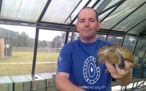
Saving turtles one smartphone at a time
Do you regularly take to the waterways? Perhaps you enjoy a spot of fishing, kayaking or swimming in your down time? As we settle into summer, many people will head to freshwater areas such as creeks and rivers to cool off and relax. Did you know that you could help turtle conservation efforts at the same time?
This year, a smartphone app and website, TurtleSAT (opens in a new window), were launched to help identify and track the number of turtles present in Australian waterways. And with the number of turtle populations in decline across south-eastern Australia – due to drought, foxes, and urban development – the app aims to become a key tool in the mapping of turtle sightings.
The app is a collaboration between UWS, The University of Sydney, NSW Department of Primary Industries, Invasive Animals CRC, The Field Naturalist Society of South Australia, the Barbara Hardy Institute at the University of South Australia and the pet food company, Fish Fuel Co.
Ricky Spencer, a zoologist in the School of Science and Health, and head of WildLab (opens in a new window), says the app is designed for quick data entry along with picture guides that will help you identify the turtle you have sighted. As phones have in-built GPS capabilities, the location is automatically recorded.
"We're hoping that everyone with a smartphone or a computer will join this unique study to map the distribution of turtles in Australian waterways," explains Ricky. "There is a turtle crisis happening at the moment, with declines of more than 90 per cent in parts of the Murray River."
Ricky says turtles play an essential role in the ecosystem. "They help maintain water health for plants and other animals by vacuuming up algae and dead material and eating young pest fish, such as European carp," he explains.
Ricky hopes that TurtleSAT will identify problem areas so that scientists can work on solutions to protect turtles in these locations. "It's about getting current and geographically accurate information so we can respond in the most efficient way to give turtles the best chance of survival," says Ricky.
TurtleSAT is free and available on iPhone (opens in a new window), iPad (opens in a new window) and Android. You can also map a turtle sighting, and find out more information about the initiative, on the TurtleSAT website (opens in a new window). Keep up to date by 'liking' the TurtleSAT Facebook page (opens in a new window) or following TurtleSAT on Twitter (opens in a new window).
Mobile options: